2025 PCT Yo-Yo Attempt
On March 25th, 2025, I will embark on the longest and most ambitious journey of my life, an out and back (or yo-yo) of the ~2,650-mile Pacific Crest Trail. This 5,300-mile journey will take me from the US Mexico Border to north of Hart's Pass in British Columbia and, hopefully, back. During my approximately 8-month long trek, I will follow the spine of the West Coast, travelling along the Laguna, Santa Rosa, San Jacinto, San Bernadino, San Gabriel, Tehachapi, Sierra Nevada, Klamath, and Cascade Mountain Ranges. The one-way PCT route contains about half a million feet of elevation gain, and a roughly equal amount of loss, for a total trip elevation gain of about a million feet. This is roughly equivalent to climbing Mt. Everest 30 times……but who's counting. This post is the first in a series of pre-hike blogs that aim to explain the route, my strategies for dealing with its obstacles, and my motivation for attempting something like this in the first place. I will be starting by going through each of the five regional segments of the PCT and explaining how I am thinking about them within the context of my journey. I hope you find this analysis interesting! Without further ado, here is my current conception of a PCT yo-yo.
The first region in the PCT is The Desert of Southern California, beginning roughly 30 miles east of San Diego. The Desert section consists of Southern Californian Mountains, classic Californian Chapparal, and a roughly 50 mile stretch through the Mojave. It is very dry, very sunny, very hot, and, semi-paradoxically, very cold at night. In my eyes, The Desert is my training ground on the way up and my cooldown on the way back. I am planning on starting my journey at the end of March which should mean cooler temperatures and more abundant water sources in the early innings of my hike. Additionally, my return journey should land me in The Desert during October/November which should also contain relatively pleasant temperatures albeit fewer available water sources. However, in my eyes, water availability is much more important at the start then at the end as more plentiful water sources means greater flexibility with early hike distances, which is essential in allowing myself to adjust my pace to my body’s needs and avoid injury. Towards the end of my hike, I should be chewing through miles like they’re candy and so flexibility will be less of a concern. This start date presents a lot of advantages in the Desert but causes an equal or greater number of problems in the next section, The Sierra.
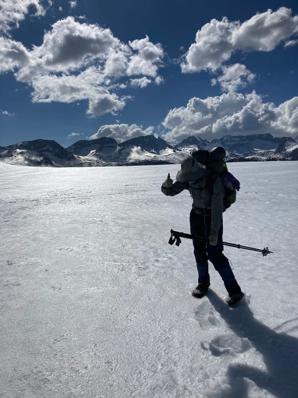
The Sierra Nevada Mountains are my most anticipated section of the trail and one of the biggest reasons for my desire to attempt a yoyo. They are rugged, remote, unforgiving, towering, and, by all accounts, awe-inspiring. Starting at the end of March and maintaining a decent pace will land me in The Sierras roughly at the end of April/start of May, which is, by most standards, an incredibly early entry and will mean that I will be likely travelling through snow for most of my northbound Sierra journey. The Sierras also contain the physical high point of the trail, the 13,000-foot Forrester Pass and the, technically an alternate, 14,500-foot Mt. Whitney. Returning through The Sierras southbound will bring me face to face with a different sort of snow problem. The trails themselves should be almost totally snow free, but a successful attempt will hinge on my ability to finish this section before the fall snowstorms make forward travel impossible. Scott Williamson, the first person to successfully complete a yo-yo, was snowed out in the Sierras four times before completing his first yo-yo, which showcases the intersection of determination and luck in completing this goal.
After leaving The Sierras, I will enter the third section of the trail, NorCal. NorCal tends to get a bad rap among PCT hikers due to being immediately preceded by the majestic Sierras and containing an increasingly often encountered obstacle to hikers, forest fires. Fires can be encountered in basically every section of the PCT, but the dryness of NorCal tends to make it a hotspot for them. Unlike snow, the only way to deal with fires is to move quickly enough to avoid them or to go around them when they occur. Starting early gives me a jump on fire season but needing to make it through NorCal twice means that once I get into NorCal going north, I’ll need to start moving quickly from there on out to give myself the best chance of avoiding anything really serious on my return journey.
After NorCal it’s off to Oregon, which is notable for containing both majestic old growth forests and hordes of ravenous mosquitos. In addition to the normal bug pressure that seems to accompany most mid-season Oregon hikes, this year has seen a historically high level of snowfall in Oregon, which means that a historically high mosquito season is well within the range of possibility. Oregon is also home to Crater Lake, one of my most anticipated destinations on the hike and, in my mind, is the point at which my desire to yo-yo will be truly put to the test. Having been on the trail for months at this point and being swarmed by hungry mosquitos will test the strength of my resolve and the limits of my sanity. Thankfully, by all accounts the return journey through Oregon should be warm, gorgeous, and, relatively, bug free.
Finally, we’ve arrived at Washington. Washington is mostly described in two ways, incredibly difficult, and supernaturally gorgeous. The Northern Cascades are the only section that seems to rival or supersede the Sierras in their grandeur, and I will be travelling through them at arguably the most beautiful time of the year. Washington will be both a payoff and a preparation. The summation of all the skills and strength I have gained from a northbound journey and a brutal and testing training ground for the speed and grit needed to make it south before the weather turns. I am hoping to complete Washington heading north between the middle of July and start of August and look forward to every step I will take in this great state. Goat Rocks wilderness in the Cascades is many people’s favorite moment of the entire trail and I can’t imagine getting to experience it not once but twice in a season.
I hope the above gives you a reasonable overview of the contours of my journey. I have never stepped foot on the trail so my assessment of the above is bound to change, as does everything that is informed primarily by theory instead of practice. I am excited for the unexpected and can’t wait to gain a new appreciation and understanding of the terrain and environment, even if it comes at the cost of a hefty helping of pain and discomfort. The remaining blog posts to be added before I start the trail will concern the gear I am bringing with me on this voyage and a smattering of training hikes I will take in preparation for my start date. Thank you so much for reading and if this was of interest to you, I would encourage you to follow along. My writing may atrophy as exhaustion does the same to my mind, but I hope that I am able to offer you an interesting glimpse into this adventure that I am undertaking. Until next time.